| 3. Historical official census places making off in South Africa | |
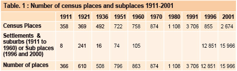
Until 1991, the localities used in the censuses correspond to the official definition of the urban object. That is, the official list of localities was drawn up in accordance with the status of these localities, which was linked to the origin of the locality and its racial composition more than to its dimensions. The existence of a local government council was the urban definition criterion until 1970. Localities with a local government body from the 1921 to 1951 census: The table provided in the CD-ROM annexes entitled “Administrative status and functions of localities” gives dates of creation and allocation of functions through the year 2000 for all localities that were local government seats and/or possessed local government status, even if only elementary (non-urban). A certain number of localities disappear as places in the course of the period: these are colonial settlement villages or missionary centers which were first identified as fully-fledged places; later, their populations of European origin declined (the case with certain missions), or they were integrated into neighboring municipalities or wider suburbs. Among the new places appearing before 1970 were villages or suburbs where the growth of the population of European origin led to their local government status and therefore urban status for the censuses. The increase in the number of urban places was thus considerable between 1931 and 1951 (rising from 492 to 722, an increase of around 50%). The censuses also make it possible to identify a certain number of localities that have no official status as an urban place but that are included in the Dysturb database (table 1). Indeed, the first censuses (1911 and 1921) included lists of towns, villages and rural settlements. In addition, up to 1960, the censuses provide lists of suburbs that are not urban localities but a breakdown of the main metropolitan areas. Finally, retrospective tables enable access to data for places appearing at a later date. In the Dysturb database, localities of this sort (non-official in statistical terms, since only urban places are taken into account) are identified as settlements. Their populations are also included in the total for rural areas in the district to which they belong, which gathers all populations outside urban places. From 1980, the main Black, Colored or Indian townships not possessing an elected council but recognized as urban localities were also considered as official census localities (urban places). This was in no way a concession to democracy on the part of the Apartheid regime but a mere accounting strategy for the black urban areas liable to be involved in forced removals toward homelands within the ‘grand apartheid’ policy. Thus, more than 350 Black townships appear as urban places in the 1980 census. In 1991, two so-called “independent” homelands, Bophuthatswana and Transkei performed an exhaustive enumeration of places in their census, i.e. all populations in each district were allocated to a certain place. Thus, for these homelands, there was no longer a non-differentiated “rural” category gathering all the populations that were not considered to belong to an urban place. This precedes the post-Apartheid practices present in the 1996 census where an exhaustive grid of more than 12,000 places was used and the census of 2001 where 2,674 main places were determined and delineated, subdivided into 15,966 subplaces (Vacchiani-Marcuzzo, 2004). The new administrative organization is indeed based on seven geographical scales, and the new subdivisions cover the entire South African territory. For the database, the correspondences between places of 1991 and prior and those of 2001 were first systematically sought in the subplaces and then for remaining localities among the main places. 0f some 4,000 localities (3,923) enumerated in 1991 or before, around 1,430 are presented in the database but have no correspondence with a main place or subplace in 2001 and no geo-referencing. For the most part (1,306 of these 1,430), they are localities noted in Transkei and Bophuthatswana in 1991 alone.
|